Lake of the Ozarks
Lake of the Ozarks directions:
From the North it can be reached on Missouri Rt. 5 south of Versailles, or from US Highway 54 southwest of Jefferson City. From the West the Lake of the Ozarks is can be reached via US Highway 65 near Warsaw. From the south it can be reached by Missouri Rt. 5 north of Lebanon, near Camdenton. Or it can be reached from the Southwest on US Highway 54 near Camdenton. The Lake of the Ozarks is centrally located only about 3 hours away from Kansas City or St. Louis and an hour north of Springfield.
It’s a good idea to have a car to get around the Lake of the Ozarks. Public transit is not available. If you have a boat, you can see most of the best areas via water.
There are taxi companies, as well as water taxis that are available.
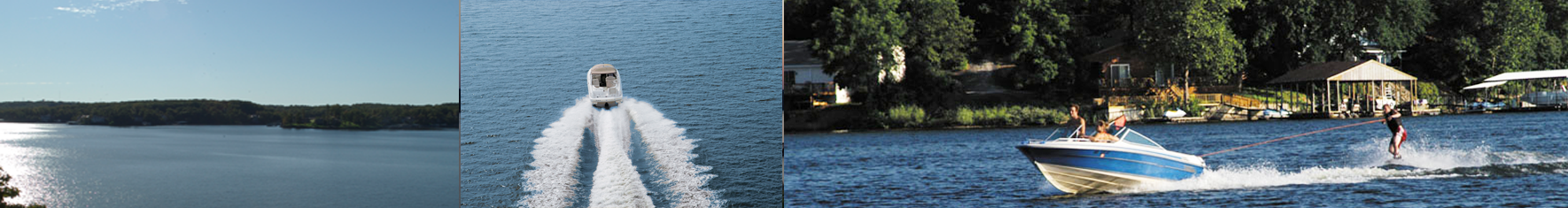
Renting a boat is a great idea! It makes for a fun day of sightseeing and visiting nice waterfront establishments, as well as seeing some very large, beautiful home properties; google it or get a map and plot the waterfront places you would like to go. Most marinas will charge around $450 for an all day Tri-toon rental. Many marinas also rent speedboats and personal watercraft for around $300, as well. Be sure to observe No Wake Zones and observe the rules/laws that the marina advises you on plus you do not want to be a pullover of the Missouri Water Patrol.
LAKE of the OZARKS AREAS
The Lake of the Ozarks is a very winding course of 93 miles (150 km) long by water with roughly 1,150 miles, the total shoreline. The common indicator for determining a lake location is the mile marker. Beginning at Bagnell Dam each mile of the lake has a marker designating how far from the dam by water you are. There are several areas with distinct names:
• North Shore – referring to the first 6 miles along the North side of the lake. It includes the town of Rocky Mount and by land can be reached via Highway W in Miller County.
• Horseshoe Bend – refers to the peninsula created by the bend in the lake along the first 17 miles of water. The area is often referred to by the main highway that runs its length “HH”. It contains many highly visited resorts, restaurants and bars. The Horseshoe Bend area contains the Village of Four Seasons which is a village or planned community in Camden County, Missouri, United States. The full time all year around population was 2,217 at the 2010 census. But the population increases dramatically seasonally. The Village of Four Seasons has a POA. The Four Seasons Lakesites Property Owner Association, Inc. encompasses approximately 7,200 properties with over 2,000 single-family homes, some multi-family residences and several associate communities consisting of both condominium and town home units. The community of Four Seasons spans over 5,000 acres and there are over 143 miles of roads within the association. Get more info here.
The Village of Four Seasons came about from the vision of Harold Koplar who was an early developer at the Lake of the Ozarks and completed construction of the Lodge in 1964. He had the idea to bring a planned community to the Lake of the Ozarks that pushed the area into a new era of development.
Along with its convenience and very close proximity to all the shopping, restaurants and lake activities there are a number of other factors that make Four Seasons a great place to own property.
The P.O.A. enforces all building and maintenance codes which show in the neat and clean outward appearance. In addition the P.O.A. offers a number of amenities to owners including access to the Kay’s Point Swim and Tennis Club, Bittersweet Pool and Regency Cove Pool. There are also parks, three fishing lakes, and a walking path the links runs through the Village of Four Seasons, and greater Horseshoe Bend. It’s the community atmosphere that is sponsored by these activities and amenities that separates this community from many others and makes it a wonderful place to vacation or call home.
• Shawnee bend – refers to the bend the lake makes immediately after Horseshoe Bend. By land it is connected to Horse Shoe Bend via the Lake of the Ozarks Community Bridge (locally known as the toll bridge).
• The West Side includes the Greenview, Sunrise Beach, Laurie and Gravois Mills areas. It’s considered the “quiet side” of the lake. By water it includes parts of the Niangua Arm, parts of the Osage Arm, the Little Niangua arm and some would consider the Gravois arm part of the Westside.
• The Grand Glaize is an arm of the lake formed where the old Glaize Creek flowed into the Osage River in modern day Osage Beach. It is home to Lake of the Ozarks State Park.
• The Gravois Arm is the Northernmost arm of the lake formed where the old Gravois Creek flowed into the Osage River near modern day Rocky Mount.
Some Nearby Towns
Barnett
Brumley
Camdenton
Eldon
Gravois Mills
Greenview
Kaiser
Lake Ozark
Lakeside
Laurie
Linn Creek
Osage Beach
Porto Cima
Rocky Mount
Sunrise Beach
Tuscumbia
Versailles
Village of Four Seasons
A very small list of things to do . . .
• Lake of the Ozarks State Park, the largest park in the state.
• See some beautiful caves.
• Cross the Swinging Bridge over Grand Glaize Creek near Brumley, MO
• Osage Beach Premium Outlets go shopping at the outlet mall in Osage Beach.
• Play the arcades and shop the Lake Ozark strip near Bagnell Dam.
• See the castle at Ha Ha Tonka State Park
• Go golfing. There are more than 13 golf courses around the lake.
– The Lodge of Four Seasons Is a championship course and one of the most challenging in the Midwest.
– Osage National Golf Club This is an Arnold Palmer layout and has imposing bluffs, creeks, lakes and large bent grass greens.
– Shawnee Bend Gold Course Is on the westside of the lake in Warsaw an is a 9-hole course.
• Go Fishing. There are more than 1300 miles of shoreline on the Lake of the Ozarks. That’s a lot of Crappie.
• Take a scenic tour on the water. Celebration Cruises http://www.celebrationlakeozark.com/